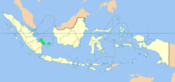
The Bangka–Belitung Islands (Indonesian: Kepulauan Bangka Belitung) is a province of Indonesia. Lying off Sumatra, the province comprises two main islands, Bangka and Belitung, and several smaller ones. In 2010 its population was 1,223,048.[1] The capital is Pangkal Pinang.
The Bangka Strait separates Sumatra and Bangka, and the Gaspar Strait separates Bangka and Belitung. The South China Sea is to the north, the Java Sea is to the south, and the province is separated from Borneo in the east by the Karimata Strait.
| Bangka–Belitung Islands Province Provinsi Kepulauan Bangka Belitung |
|||
|---|---|---|---|
| Province | |||
| Downtown Pangkal Pinang, the largest town of the province | |||
|
|||
| Motto: Serumpun Sebalai (Malay) (The same root, the same place) |
|||
| Location of Bangka–Belitung in Indonesia | |||
| Coordinates: 2°8′S 106°7′ECoordinates: 2°8′S 106°7′E | |||
| Country | Indonesia | ||
| Capital | Pangkal Pinang | ||
| Government | |||
| • Governor | Rustam Effendi | ||
| Area | |||
| • Total | 16,424.14 km2 (6,341.40 sq mi) | ||
| Population [1] | |||
| • Total | 1,223,048 | ||
| • Density | 74/km2 (190/sq mi) | ||
| Demographics | |||
| • Ethnic groups | Malays (72%), Chinese (12%), Javanese (6%), Buginese (3%), Madurese (1%), Sundanese (1%) | ||
| • Religion | Muslim (82%), Buddhist (4.24%), Confucianism (3.25%), Protestantism (1.8%), Roman Catholicism (1.2%), Hindu (0.09%)[2] | ||
| • Languages | Indonesian, Malay, Hakka (Chinese) | ||
| Time zone | WIB (UTC+7) | ||
| Website | www.babelprov.go.id | ||
History
The first Chinese workers who came to Indonesia were mainly men. They began assimilating with local people and intermarriages followed, residents coexisting peacefully in spite of differences in religion and ethnicity. When anti-Chinese riots occurred in some parts of Indonesia in 1998 at the end of the Soeharto regime, local people and those of Chinese descent lived peacefully in the Bangka Belitung province.[3]The province was formerly part of South Sumatra, but became a separate province along with Banten and Gorontalo in 2000.
Economy
These islands are the largest producer of tin in Indonesia. white pepper is also produced.Health
According to the Indonesian Health Department, Bangka Belitung is highly malarious area. The annual malaria incidence rate in Bangka Belitung is reported as 29.3/1000 population.[4]Administrative divisions
Bangka-Belitung is divided into six regencies and one city, below with their (provisional) populations at the 2010 Census.| Name | Area (km2) | Population Estimate 2005 |
Population Census 2010 |
Capital |
|---|---|---|---|---|
| Pangkal Pinang (city) | 118.80 | 145,945 | 174,838 | Pangkal Pinang |
| Bangka Regency | 2,950.69 | 246,579 | 277,193 | Sungailiat |
| West Bangka Regency (Bangka Barat) | 2,820.61 | 147,855 | 175,110 | Muntok |
| South Bangka Regency (Bangka Selatan) | 3,607.08 | 148,912 | 172,476 | Toboali |
| Central Bangka Regency (Bangka Tengah) | 2,126.36 | 133,380 | 161,075 | Koba |
| Total Bangka | 11,623.54 | 822,671 | 960,692 | |
| Belitung Regency | 2,293.69 | 132,777 | 155,925 | Tanjung Pandan |
| East Belitung Regency (Belitung Timur) | 2,506.91 | 87,380 | 106,432 | Manggar |
| Total Belitung | 4,800.60 | 220,157 | 262,357 |


0 komentar:
Posting Komentar