East Java (Indonesian: Jawa Timur, Javanese: Jawa Wétan) is a province of Indonesia. It is located on the eastern part of the island of Java and includes the neighbouring islands of Madura, and the Kangean, Sapudi, Bawean, and Masalembu groups.
Its capital is Surabaya, the second largest city in Indonesia and a major industrial center and port. It covers an area of 47,922 km2. At the 2010 Census, the province's population was 37,476,000.
It has a land border only with the province of Central Java to the west, being surrounded by sea on all other sides.
| East Java Province Provinsi Jawa Timur |
|||
|---|---|---|---|
| Province | |||
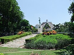
| Bahari Monument, Jalan Darmo, Surabaya | |||
|
|||
| Motto: Jer Basuki Mawa Béya (Javanese) (meaning: Efforts are needed to get success or prosper) |
|||
| Location of East Java in Indonesia | |||
| Coordinates: 7°16′S 112°45′ECoordinates: 7°16′S 112°45′E | |||
| Country | Indonesia | ||
| Capital | Surabaya | ||
| Government | |||
| • Governor | Dr. H. Soekarwo, S.H., M.Hum. | ||
| Area | |||
| • Total | 47,922 km2 (18,503 sq mi) | ||
| Population (2010) | |||
| • Total | 37,476,011 | ||
| • Density | 780/km2 (2,000/sq mi) | ||
| Demographics | |||
| • Ethnic groups | Javanese (79%), Madurese (18%), Osing (1%), Chinese (1%)[1] | ||
| • Religion | Islam (96.36%), Christianity (2.4%), Buddhism (0.6%), Hinduism (0.5%), Confucianism 0.1%, Kejawen also practised[2] | ||
| • Languages | Indonesian, Javanese, Madurese | ||
| Time zone | WIB (UTC+7) | ||
| Website | www.jatimprov.go.id | ||
History
East Java's history dates back to the famous ancient kingdoms of Kediri and Singosari, which is now a city near Malang. The Majapahit empire, centered at Trowulan, Mojokerto East Java, is celebrated by Indonesians as the golden age of the archipelago. Most of the Eastern Java region was part of the Mataram Kingdom during its peak, apart from the Kingdom of Blambangan at Java's far eastern end nearest to Bali.Administrative divisions
-
See also: Subdivisions of Indonesia and Districts of East Java
| Name | Capital | Area (in km²) |
Population 2000 Census |
Population 2005 estimate |
Population 2010 Census |
|---|---|---|---|---|---|
| Surabaya City | Surabaya | 374.78 | 2,599,796 | 2,611,506 | 2,765,908 |
| Gresik Regency (includes Bawean Island) |
Gresik | 1,005,445 | 1,118,841 | 1,177,201 | |
| Lamongan Regency | Lamongan | 1,181,660 | 1,187,065 | 1,179,770 | |
| Mojokerto Regency | Mojokerto | 908,004 | 969,299 | 1,023,526 | |
| Mojokerto City | Mojokerto | 108,938 | 111,860 | 120,132 | |
| Sidoarjo Regency | Sidoarjo | 634.89 | 1,563,015 | 1,697,435 | 1,945,252 |
| Pasuruan Regency | Pasuruan | 1,474 | 1,366,605 | 1,398,122 | 1,510,261 |
| Pasuruan City | Pasuruan | 168,323 | 171,136 | 186,322 | |
| Surabaya Sub-regional Totals | |||||
| Tuban Regency | Tuban | 1,051,999 | 1,063,375 | 1,117,539 | |
| Bojonegoro Regency | Bojonegoro | 1,165,401 | 1,228,939 | 1,209,008 | |
| Ngawi Regency | Ngawi | 813,228 | 827,728 | 817,076 | |
| Magetan Regency | Magetan | 615,254 | 617,492 | 620,146 | |
| Madiun Regency | Madiun | 639,825 | 641,596 | 661,886 | |
| Madiun City | Madiun | 163,956 | 171,390 | 170,851 | |
| Nganjuk Regency | Nganjuk | 973,472 | 989,693 | 1,016,393 | |
| Jombang Regency | Jombang | 1,126,930 | 1,222,499 | 1,201,557 | |
| Northwest Sub-regional Totals | |||||
| Probolinggo Regency | Probolinggo | 1,004,967 | 1,021,279 | 1,095,370 | |
| Probolinggo City | Probolinggo | 191,522 | 211,142 | 216,967 | |
| Situbondo Regency | Situbondo | 1,638.15 | 603,705 | 605,208 | 647,500 |
| Bondowoso Regency | Bondowoso | 688,651 | 698,504 | 736,530 | |
| Banyuwangi Regency | Banyuwangi | 5,782.50 | 1,488,791 | 1,514,605 | 1,554,997 |
| Jember Regency | Jember | 3,293.34 | 2,187,657 | 2,261,477 | 2,346,498 |
| Lumajang Regency | Lumajang | 965,192 | 999,525 | 1,006,563 | |
| Far Southeast Sub-regional Totals | 7,130,485 | 7,311,740 | 7,604,425 | ||
| Malang Regency | Kepanjen | 2,412,570 | 2,336,363 | 2,443,609 | |
| Malang City | Malang | 756,982 | 790,356 | 819,708 | |
| Batu City | Batu | (included in Malang Regency) |
179,092 | 189,793 | |
| Kediri Regency | Kediri | 1,408,353 | 1,429,137 | 1,498,803 | |
| Kediri City | Kediri | 244,519 | 248,640 | 267,435 | |
| Blitar Regency | Kanigoro | 1,064,643 | 1,065,838 | 1,116,010 | |
| Blitar City | Blitar | 119,372 | 126,776 | 132,018 | |
| Tulungagung Regency | Tulungagung | 929,833 | 969,461 | 989,821 | |
| Trenggalek Regency | Trenggalek | 649,883 | 665,070 | 674,521 | |
| Ponorogo Regency | Ponorogo | 841,449 | 869,642 | 854,878 | |
| Pacitan Regency | Pacitan | 525,758 | 545,670 | 540,516 | |
| Southern Sub-regional Totals | 8,953,362 | 9,226,045 | 9,527,112 | ||
| East Java (excluding Madura) Totals |
43,508 | 31,535,693 | 32,565,761 | 33,854,365 | |
| Bangkalan Regency | Bangkalan | 1,260 | 805,048 | 889,590 | 907,255 |
| Sampang Regency | Sampang | 1,152 | 750,046 | 835,122 | 876,950 |
| Pamekasan Regency | Pamekasan | 733 | 689,225 | 762,876 | 795,526 |
| Sumenep Regency | Sumenep | 1,147 | 985,981 | 1,004,758 | 1,041,915 |
| Madura Totals | 4,292 | 3,230,300 | 3,492,346 | 3,621,646 | |
| Total for Province | 47,800 | 34,765,993 | 36,058,107 | 37,476,011 |
Demography
| Historical population | ||
|---|---|---|
| Year | Pop. | ±% |
| 1971 | 25,516,999 | — |
| 1980 | 29,188,852 | +14.4% |
| 1990 | 32,503,991 | +11.4% |
| 1995 | 33,844,002 | +4.1% |
| 2000 | 34,783,640 | +2.8% |
| 2010 | 37,476,757 | +7.7% |
| Source: Badan Pusat Statistik 2010 | ||
According to the 2000 census, East Java had 34,765,993 inhabitants, which increased to 37,476,011 at the 2010 Census,[3] making it the second most populous Indonesian province after West Java. The inhabitants are predominantly ethnically Javanese. Native minorities include migrants from nearby Madura, and distinct Javanese ethnicities such as the Tengger people in Bromo, the Samin and the Osing people in Banyuwangi. East Java also hosts a significant population of other ethnic groups, such as Chinese, Indians, and Arabs. In addition to the national language, Indonesian, they also speak Javanese. Javanese as spoken in the western East Java is a similar dialect to the one spoken in nearby Central Java, with its hierarchy of high, medium, and low registers. In the eastern cities of Surabaya, Malang, and surrounding areas, a more egalitarian version of Javanese is spoken, with less regard for hierarchy and a richer vocabulary for vulgarity.
Madurese is spoken by around 15 million ethnic Madurese, and is concentrated in Madura Island, Kangean Islands, Masalembu Islands, the eastern parts of East Java, and East Java's larger cities.
Religion
Hinduism and Buddhism once dominated the island; however Islam gradually supplanted Hinduism in the 14th and 15th centuries (see the spread of Islam in Indonesia). The last nobles and loyalists of the fallen empire of Majapahit fled from this point to Bali. Islam spread from northern cities in Java where traders from Gujarat, India brought with them Islam. The eastern part of East Java, from Surabaya to Pasuruan, and the cities along the coast, and back to Banyuwangi to Jember, are known as the "horseshoe area" in context with earlier Muslim communities living there.[citation needed]Pockets of Hinduism remain, and syncretic abangan streams of Islam and Hinduism remain strong (see Hinduism in Java).
Natural resources
- Chalk (Trenggalek & Gresik the city is also famous of its cement industries)
- Marble (Tulungagung)
- Petroleum (Bojonegoro)
- Salt (Madura Island)
- Kaolinite (Blitar)
- Sulfur
Seaports
East Java will build 4 seaports by 2013 in Lamongan, Gresik, Probolinggo and Banyuwangi.[4]Education
East Java hosts some of the famous universities in Indonesia, both owned by government and private. Three major cities for universities, because they have government's universities, are Surabaya, Malang, and Jember. Among them, Airlangga University and Institut Teknologi Sepuluh Nopember are the most famous, and both are located in Surabaya. See: List of universities in East JavaAnother important form of education that is available in most cities in East Java is the pesantren. This kind of education is built and organized by Islamic clerics, and associated with local or national Muslim organizations. Jombang is a famous city for its pesantren.
Media
East Java supports several regional media outlets. Local newspapers with provincial news reach their readers earlier than their competitors from Jakarta. In the spirit of "providing more news from around readers", most newspapers even issue municipal sections which are different among their distribution areas.- Jawa Pos Group, one of the major newspaper groups in Indonesia, is based in Surabaya.
- Surya, is a newspaper based in Surabaya. Surya is now controlled by Kompas, one of the major newspaper groups in Indonesia
National parks
- Meru Betiri National Park - Between Jember and Banyuwangi districts, this park covers 580 km2 (224 sq mi). Hard to get to, it contains fantastic coastal rainforest and scenery and is home to abundant wildlife.
- Alas Purwo National Park - This 434 km2 (168 sq mi) park is formed by the Blambangan Peninsula (south eastern Java). Comprising mangrove, savanna, lowland monsoon forests and excellent beaches, the park's name means First Forest in Javanese. Javanese legend says that the earth first emerged from the ocean here.
- Baluran National Park - This 250 km2 (97 sq mi) national park is located in north east Java, once known as Indonesia's little piece of Africa, the parks formerly extensive savanna has been largely replaced by Acacia.
- Bromo Tengger Semeru National Park - Located in East Java at the region of Probolinggo and Pasuruan, 70 km (43 mi) from Surabaya the capital city of East Java province. Mount Bromo is one of the great hiking and trekking destinations for overseas tourists. The breathtaking view of Bromo also attracts hundreds of photo enthusiasts to see the views there.
Local economic governance
Based on the survey conducted between August 2010 and January 2011, East Java included 11 of the top 20 cities and regencies of the Local economic governance which measures nine parameters: [5]- infrastructure
- private enterprises development program
- access to land
- interaction between local administrations and businesses
- business licensing
- local taxes and fees
- security and business conflict resolution
- capacity and integrity of regional heads
- quality of local regulations
- Blitar, East Java
- North Lampung Regency, Lampung
- Probolinggo, East Java
- Batu, East Java
- Sorong Regency, West Papua


0 komentar:
Posting Komentar